
UAB Barcelona Hosts ‘El Pirineo sin Briet’: 100 Years of Landscape Change in the Pyrenees
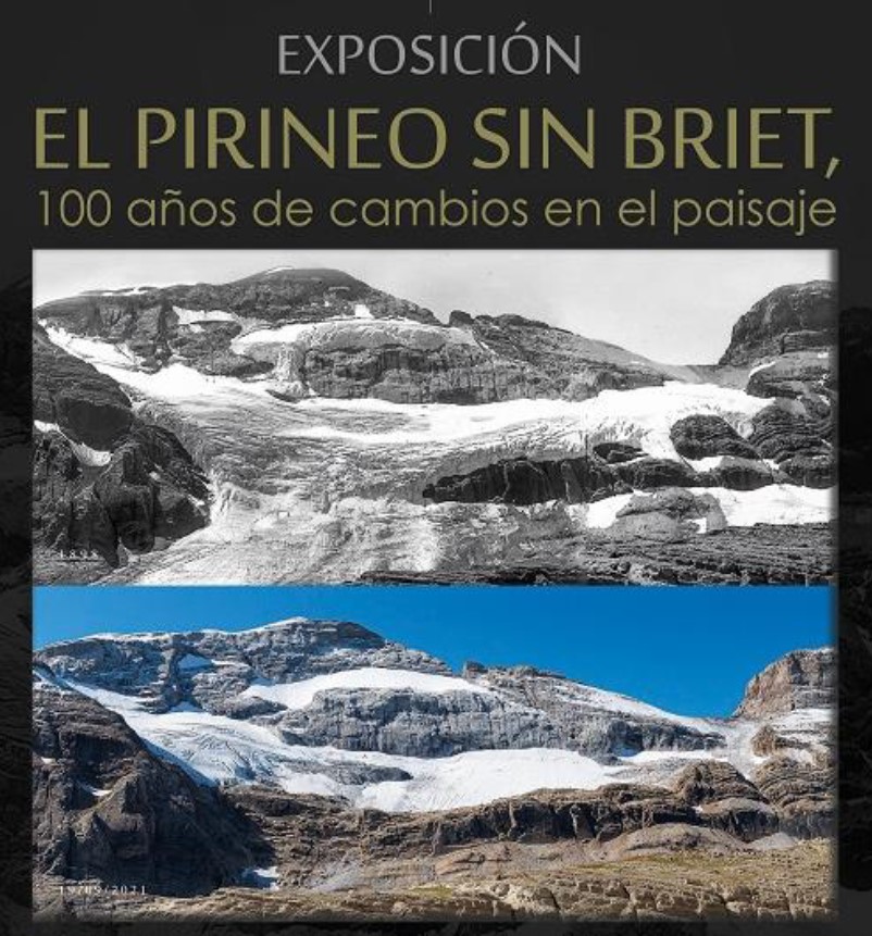
On April 24, the Universitat Autònoma de Barcelona (UAB) opened the exhibition El Pirineo sin Briet, marking a centenary of photographic and scientific documentation of the Pyrenees. The event, located in the Sala Tarot de Quinze within the Faculty of Philosophy and Letters, serves as a meeting point for geographers, historians, conservationists and the general public to examine the dramatic evolution of this mountain range over the last century.
Why the Exhibition Matters for Geography Students and Professionals
The Pyrenees span the border between Spain and France, and have long attracted scholars because of their complex geology, rich biodiversity and the cultural tapestry woven by the communities that inhabit them. El Pirineo sin Briet provides an unprecedented visual timeline that allows participants to see tangible evidence of natural processes—glacial retreat, river meandering and slope stabilisation—alongside human interventions such as forestry practices and tourism development. For students pursuing degrees in physical geography, geomorphology, or environmental science, the exhibition offers a real‑world case study that complements textbook learning.
Lucien Briet: The Father of Pyrenean Photography
Central to the opening of the exhibition is Lucien Briet (1860‑1921), a Parisian explorer who spent decades photographing the Aragonese Pyrenees. Briet’s images are more than aesthetic records; they are scientific archives that allow modern researchers to quantify landscape change. His work was instrumental in the designation of Ordesa as Spain’s first National Park in 1918, a milestone that set a precedent for protected area creation across the Iberian Peninsula.
Scientific Coordination by Anchel Belmonte
Anchel Belmonte, scientific coordinator of the UNESCO Global Geopark Sobrarbe‑Pyrenees, delivered the keynote address at precisely 12:00 p.m. during the opening ceremony. Belmonte highlighted how the Geopark’s mission to preserve natural heritage aligns with Briet’s legacy, and underscored the importance of integrating historical data with contemporary monitoring techniques such as LiDAR and satellite imagery.
The Geological Lens: Observing 100 Years of Change
Each photograph in the collection is paired with commentary that situates the image within a geological context. By comparing 19th‑century field trips with 21st‑century observations, researchers can assess rates of erosion, shifts in alpine vegetation and the extent of glacial melt. For example, the series of images depicting the Aigües River cutting through the valley reveal a clear widening of its channel over time, a process attributed to both natural sediment transport and increased water flow during warmer summers.
Glacial Retreat in the Sobrarbe Section
The exhibition foregrounds the dramatic disappearance of small alpine glaciers across the Sobrarbe region. Briet’s photographs of lingering ice patches in the early 1900s contrast sharply with the barren moraine landscapes captured in the 1990 s and later. This visual evidence supports climate‑change data collected by the UAB’s Department of Atmospheric Sciences, reinforcing the message that temperature rises are accelerating geological transformations in the Pyrenees.
Human Impact: Agriculture, Tourism and Conservation
Besides natural processes, the exhibition examines how human activity has sculpted the landscape. Briet’s meticulous documentation of terraced vineyards and pastoral pastures provides insight into centuries of land use. Recent photos show the expansion of hiking infrastructure, the construction of mountain refuges, and the establishment of new footpaths. By overlaying these photographs with GIS maps, visitors can identify areas where conservation efforts have mitigated damage and where further action is required.
UNESCO Global Geopark Sobrarbe‑Pyrenees: Connecting History to Future Protection
The Geopark, co‑hosted by the Sobrarbe Region, operates under UNESCO’s Global Geopark network. Its focus on integrated conservation, research and sustainable tourism aligns with the exhibition’s themes. The Geopark’s educational programs train local guides, create interpretive trails and support scientific studies that monitor soil erosion, biodiversity loss and visitor impact.
Collaborative Research Initiatives
University‑Geopark joint projects are highlighted in a dedicated section of the exhibition. These projects involve field campaigns where undergraduate and postgraduate students gather data on soil composition, slope stability and hydrological patterns. By involving students in hands‑on research, the Geopark fosters a new generation of geoscientists committed to site preservation.
Managing the Balance Between Access and Preservation
The exhibition’s narrative also tackles a perennial issue: how to allow public access to scenic sites while preventing degradation. Through model simulations presented in the exhibition, visitors see how limiting visitor numbers in high‑traffic areas, installing boardwalks over fragile zones and enforcing seasonal closures help sustain ecological balance.
Highlights of the Exhibition Space
- Photographic Timeline: Over 200 images ranging from 1883 to 2020, displayed in chronological order.
- Interactive Digital Map: Allows visitors to click on a location and view the evolution of the terrain over time.
- Audio Guides: Available in Spanish, Catalan and English; narrators describe geological phenomena in layman’s terms.
- Hands‑On Activity Corner: Visitors can experiment with sediment trapping and erosion simulation kits.
- Downloadable Dossier: A PDF containing high‑resolution images, research notes and contact information for further inquiry.
How to Engage Further: From the Classroom to the Field
Educational stakeholders will find several pathways to integrate the exhibition’s material into their curricula:
- Virtual Tour: The UAB website hosts a 360° walk‑through that schools can embed in online modules.
- Field Trip Coordination: The Department of Geography offers coordinated visits to the Geopark, supplemented with pre‑fieldwork lectures.
- Research Collaboration: Graduate students can apply for project funding to analyze data sets released by the Geopark.
- Public Lectures: The annual Pyrenees Symposium continues the dialogue, featuring researchers covering geomorphology, climatology and cultural heritage.
Taking the Next Step
Students or enthusiasts interested in the dynamic systems of the Pyrenees can start by:
- Downloading the full exhibition dossier from the UAB site;
- Subscribing to the UAB Geography Newsletter for updates on upcoming events;
- Planning a visit to the Faculty of Philosophy and Letters to view the exhibition in person or to arrange a guided tour;
- Reaching out to the Department’s faculty to discuss potential research collaborations.
For the general public, the exhibition offers a powerful reminder that landscapes are not static. They evolve with every freeze‑thaw cycle, every storm and every human decision. By understanding these changes, we can better plan for resilient communities and preserve the natural beauty that defines the Pyrenees for future generations.
Contact and Further Resources
- UAB Geography Department: [email protected] – For questions or collaboration inquiries.
- Visit the Pavilion: Sala Tarot de Quinze, Faculty of Philosophy and Letters, UAB – Open daily 10:00 a.m. to 6:00 p.m.
- Subscribe to the Newsletter: Sign up here to receive future announcements.
- Download the Exhibition Dossier: Access the PDF for detailed images and commentary.
- Explore the Geopark’s Resources: Official Sobrarbe‑Pyrenees Geopark – Learn more about ongoing conservation efforts.
Keep engaged with the UAB’s broader geographical outreach by following our social media channels and attending forthcoming events that illuminate the science of our planet’s changing landscapes.