
The Green Ring of Terrassa—an expansive natural area covering more than 4,000 hectares—has become an integral part of the second‑year curriculum for the Bachelor’s degree in Geography, Environment, and Territorial Planning (GMAiPT) at the Autonomous University of Barcelona (UAB). By integrating a real‑world ecosystem into classroom learning, the program equips students with the analytical tools and field experience required for modern environmental and spatial planning roles.
Why the Green Ring Matters in Contemporary Planning
Terrassa’s Green Ring is not just a patch of forest; it is a living laboratory that illustrates the challenges of balancing urban growth with ecological preservation. The area covers 65% of the municipality’s territory, representing a critical green space that serves as a habitat corridor, a carbon sink, and a recreational resource for local residents. For students, studying this space offers concrete insight into:
- Urban‑rural interface dynamics
- Biodiversity conservation strategies
- Sustainable land‑use zoning and policy frameworks
- Community engagement and participatory governance
Integrating Theory and Practice at UAB
UAB’s Faculty of Philosophy and Arts champions a challenge‑based learning approach. This methodology moves beyond textbook theory, encouraging students to confront contemporary territorial problems and devise realistic solutions. The Green Ring project demonstrates this pedagogy in action: students work in interdisciplinary teams, analyze stakeholder‑generated data, and craft comprehensive diagnostic reports.
Course Placement: Territorial and Environmental Laboratory
The “Territorial and Environmental Laboratory: Memory” course, coordinated by Antoni Durà and Mario Padial, forms the backbone of the second‑year program. The course emphasizes problem identification, diagnostic processes, and evidence‑based recommendations—skills that are essential for practitioners in municipal planning, environmental consultancy, and regional development.
Course Placement: Qualitative Methods and Fieldwork
Complementing the laboratory is the “Qualitative Methods and Fieldwork” course taught by Antonio Miguel Solana, Àngels Pérez, and Mar Esteve. This module grounds theoretical knowledge in field experience, concentrating on data collection techniques such as participatory mapping, stakeholder interviews, and GIS analysis. Together, these courses provide a full spectrum of competencies from conceptual design to on‑the‑ground execution.
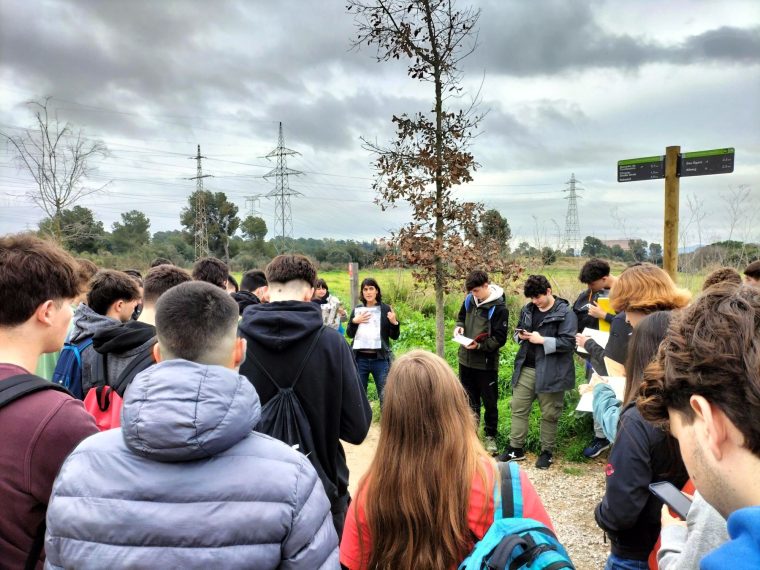
Fieldwork: Methods and Insights
Students’ interaction with the Green Ring begins with a briefing led by Marga Rodríguez, head of the Natural Resources and Sustainability Service of Terrassa City Council. Following the orientation, two guided treks were organized:
- March 11 – Torrebonica and Can Canya route: A foundational walk that introduced students to key ecological zones and historical land use.
- March 18 – Les Martines area: A deeper dive into the core of the Green Ring, focusing on biodiversity hotspots and anthropogenic pressures.
During these trips, students collected quantitative data (soil samples, vegetation indices) and qualitative observations (community narratives, observed land‑use patterns). Faculty members—Antoni Durà, Àngels Pérez, Mar Esteve—and Terrassa technician Carol Salmerón-Marí facilitated interactive discussions on site.
Stakeholder Engagement and Collaborative Diagnosis
A distinctive element of the Green Ring case study is its stakeholder‑led problem definition. Local residents, business owners, and council officials identified pressing issues such as invasive species proliferation, uneven recreational access, and conflicting land‑use demands.
Students reviewed these concerns, applied diagnostic frameworks from their coursework, and crafted a comprehensive report. The report encompassed:
- Spatial analysis using GIS layers for land cover, topography, and human infrastructure.
- Risk assessment matrices for ecological threats.
- Stakeholder priority matrices derived from qualitative interviews.
- Scenario planning for future land‑use management.
Later, the diagnostic outcomes were presented orally in front of the council representatives, providing a realistic experience in professional communication and policy influence.
Developing Practical Skill Sets
Through the Green Ring project, students strengthened a range of transferable skills:
- Technical GIS proficiency – Mapping, spatial interpolation, and thematic analysis.
- Field survey methodology – Sampling protocols, data validation, and safety procedures.
- Stakeholder listening and negotiation – Capturing diverse perspectives and building consensus.
- Policy translation – Converting scientific insights into actionable recommendations.
These capabilities align with the current demands of environmental agencies, sustainable infrastructure firms, and consultancies that require hands‑on experience and concrete results.
Future Applications and Career Benefits
Graduates who have completed the Green Ring module bring a unique blend of experiential knowledge and academic grounding to the workforce. Typical career paths include:
- Environmental planner within municipal or regional authorities.
- GIS analyst in transportation, utilities, or ecological research.
- Sustainability consultant for private sector projects.
- Urban economist or policy analyst focusing on green infrastructure.
Moreover, the project fosters a network of alumni who remain active in Terrassa’s environmental initiatives, providing a bridge between academic training and professional practice.
How to Get Involved: Apply to UAB’s GMAiPT Program
Students interested in hands‑on environmental planning can apply to the Bachelor’s degree in Geography, Environment, and Territorial Planning at UAB. The program’s unique emphasis on real‑world problem solving, demonstrated by the Green Ring case study, prepares graduates for immediate impact in the field.
Currently, the university is accepting applications for the upcoming academic year. Prospective applicants are encouraged to:
- Review the program curriculum and course offerings on the UAB Geography Department website.
- Contact the admissions office for information about entrance requirements and financial aid.
- Attend an open house or virtual orientation to meet faculty and current students.
Conclusion
The Green Ring of Terrassa exemplifies how immersive field studies can enhance academic rigor and professional readiness. By embedding this natural area into the second‑year curriculum, UAB demonstrates its commitment to producing graduates who are ready to tackle the environmental and planning challenges of the 21st century.
Interested individuals can learn more about the program and upcoming application deadlines by visiting UAB Geography Department.
—
Apply now to join UAB’s Geography, Environment, and Territorial Planning degree and experience the Green Ring’s real‑world learning here.
Discover how participation can shape your career by exploring related course modules and faculty research here.
Contact the department for specific inquiries about fieldwork opportunities or program structure here.
Stay informed on similar case studies and updates by subscribing to UAB’s geography newsletter here.